Syanzururu means – Glacier in the local Lukonjo language spoken in the Kasese/Rwenzori area. And this was the name of our wonderful expedition - with a mission!!!!
The night before the start of this expedition – well it was an expedition as a matter of fact – I lay in bed thinking whether I was both mentally and physically ready for this trek. How was to judge anyhow? I had read and heard so much about the Rwenzori that I honestly had no way of being a self-judge. It suddenly dawned on me – as I lay there – this would be the last time I would have a comfortable, double bed with cosy pillows in 8 days!!!!! I put my devils to rest and told myself – I WAS READY!!!!
Day 1:
Bright and early – after, I must confess, a deep soak in the bath tub – we set out to meet with the rest of team from the Uganda Wildlife Authority and the guides from the Rwenzori Mountaineering Services (RMS) offices – this is a community based organization based in Kasese. These guys were simply our guardian angels….you will understand why later.

The guides - L-R - Josephat, Stephen, Anthony and Herbert
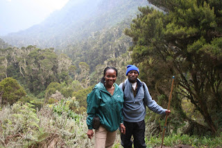
We were just ready to ROCK!!! Armed with walking sticks and renewed energy – here we are….

After a briefing of what the trip would be like, which camps we would stop at when etc. we set off at 10:00am on 20th February 2008. Onward marching solders……
Here we are…..

We reached the park entrance – for more briefing yet again – just before we entered the boundaries of the Rwenzori National Park. We were well informed not only by the wardens but also the amazing signage within the park.
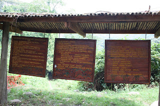
I was by now mentally prepared for the zones I was being informed of – mountane forest area this, bamboo forest that….very ready now.
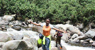
Then it all began – THE ASCENT!!!! Inially not very steeply, gentle walk, green broad-leaved vegetation all around. Lovely. Then we walked passed the wonderful Mubuku River – very rocky and refilled our water bottles – that were interestingly labeled – Rwenzori spring water..hahhahahhaa. NICE – we got the real deal. To be honest I cannot remember when I last drank water naturally provided – from the source!!!
 Pretty natural things and medicinal plants….was the dose of sights we got as we walked on and the guides talked on….
 Sausage Tree – Kigelia africana – known for its medicinal properties including its usefulness to men especially those suffering from ..mmmm…..well that’s what the guide whispered to me. I just smiled back.

Even more interesting things…..the one horned chameleon – now this was fascinating for me. I had never seen one before. Gorgeous creature!!!

Some interesting mushrooms too – I didn’t dare taste lest my trek ended right here.
And then we got to Mahoma River – that’s when the real ascent started…..wow…..and questions also began – So how long does this stretch go for? We will sight a glacier or two? How high will it be when we get to base camp?

I guess I was just trying to get my mind off the steepness of the trail – but what a climb. Up and up AND up……

After a nearly 5 hour trek – we sighted Nyabitaba Base Camp..Hallelujah!!!!!!
Hang on…not just the camp but the misty hill range of the mountain that changed from minute to minute…..and the magnificent Portal Peaks – Incredible!!!!!! Uhhh it was such a magical moment.
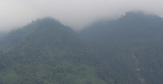


For failure of finding the right words to describe this – all I can say is that it was a bit like a theatrical dance – exciting at every turn – I mean how else can I describe it?
*******
Day 2
Had I forgotten what camping during the Girl Guide days was like? Ohhh after a night on a hard bed and a sleeping bag, I was just ready to go. But not without the very first breakfast at Nyabitaba Camp.

I took the last picture of the Portal peaks just before we left because Herbert one of the guides told me that in a few days time these rather high and challenging looking peaks will be dwarfed by the real things…hehhehehhee.


Herbert talking to team….

Beaming with renewed energy – Me - we started the trek for a second day.
We started yet another day of further ascent and I mean getting to higher elevation. This part of the trek was not as steep as the day before. We crossed the rather “giddy” Kurt Schafer Bridge which – last November – had suffered a freak of nature and was hit by a big log coming from upstream. The result – this bridge:


I survived this.
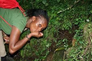
Though it was not incredibly warm, thirst was something we had to contend with. Steep hills translated to regular watering stops – from nature yet again:

More walking. I couldn’t but marvel at the amazing plant life along the way. I was lucky to be walking closely with Stephen, a rather knowledgeable and a man who new a fair amount of info on medicinal plants. Amazing.
For example – I was struck by the beauty of the flowers of this plant below. His response to its use even dazzled me more –

Locally known as “Lhukonzo” in the Lukonjo language – this plant (with the pretty orange flowers) is locally used to remove evil spirits.

This was locally known as a snake head – perhaps because it looked like one. It seemed not to have medicinal value – but hey not everything does.
More on the beautiful flora of this stunning landscape – here is a sneak preview:
 Satyrium robusta
 in bloom

Pretty and nearly ready to eat – raspberry fruit in the wild

And accompanying raspberry flowers in bloom too

Some phenomenally pretty mushroom growing on a bark of a tree with some ferns
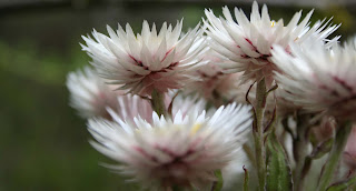
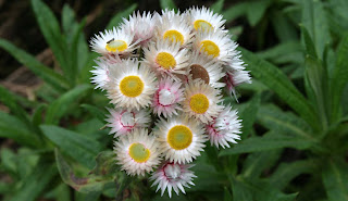
Everlasting flowers – Helichrysum guilemii – in bloom; these amazingly stunning flowers only open up fully in direct sunlight. They close at night or when it’s raining. Superb.


The sight of some kind of fern growing on trees is incredible. These fern seem to have some type of symbiotic relationship with the Heather trees.

Fern shoot in its initial life stages….coiled up – cute.
Then we walked through a rather exciting zone for me – the Bamboo zone. Breath taking. An incredibly lush and misty zone, it was simply beautiful – more so with the fern that either entwined it….or grew between the joints of the bamboo stems.
I certainly cannot ignore the Fauna…..and gorgeous looking Cha…..here we come….

The sighting of this chameleon was rather unusual in sense that it was actually sighted at elevation of over 3,000 masl – where most of these creatures are rarely found. This was, in a way indicative of the changes that were taking place within this rather delicate environment – it warming up.
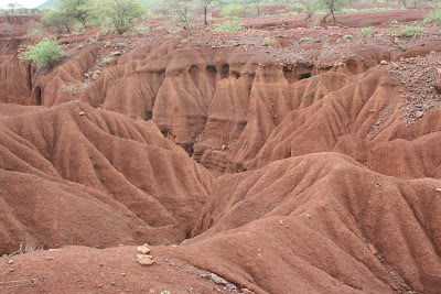
With all this beauty – nature surely does have a way of popping up with surprises. After walking for slightly over an hour, we came to a rather interesting junction. An entire part of a hill had been defaced and a landslide had taken place, last November. I gather from those that had heard the noise when it happened – it was deafening and wild. It seems this is largest of its kind in Africa within a mountain range. I would not disagree as I have never seen anything like this to make any comparison. I stood on what seemed to be the remnant of a “sea of mud and rock”……with debris everywhere of brunches and uprooted massive trees. This must have been an event of a kind – check this out:


We climbed some more – in some places not so pleasant. Is a trek ever meant to be trouble-free? I doubt it. Then it would be no journey at all…hehhehhehehe

A rather muddy and not so good part of the trail.
We made it to John Matte camp in just less than 6 hours. This time we had reached elevation 3,900 meters above sea level. Yihooooooo.


+and+Nyangores+(R)+Mara+River+middle.JPG)

 The view of the lake sort of reminded me of a large sting ray with a tail – don’t you think?


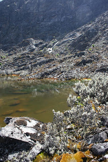


 As I have indicated in my earlier write up – the vegetation of this ecosystem is incredible. Here are some pictures of the wonderful scenes of the floral at just over 3,000m....

 This is a young everlasting flower plant encassed in some web-like thing. It was just amazing.
 Everlasting flowers.....in blooom...


